Live The High Life
Real offroad expeditions, routes, and rallies.
Live The High Life
Real offroad expeditions, routes, and rallies.
Hidden deep inside the eastern Kumaon Himalayas of Uttarakhand, near the borders of India, Nepal and China, Lipulekh Pass stands as one of the most historically significant and strategically important mountain passes in the Indian Himalayas.
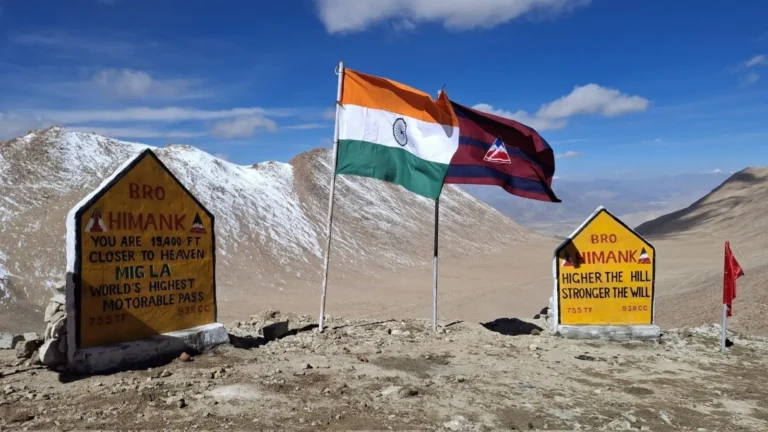
At an altitude of around 17,500 feet (5,334 meters), Lipulekh Pass is not just a border crossing — it is an ancient Himalayan trade route, a spiritual gateway for pilgrims heading toward Mount Kailash and Lake Manasarovar, and a dream destination for hardcore mountain travelers who crave raw terrain, remote valleys, and real expedition energy.
For the overlanding community, Lipulekh Pass represents something bigger than a destination. It represents the spirit of Himalayan exploration — rough roads, unpredictable weather, military checkpoints, isolated villages, and landscapes that make you feel tiny against the scale of the mountains.


Lipulekh Pass lies in the Pithoragarh district of Kumaon and forms part of the greater Himalayan frontier region known for its rugged terrain and sensitive geopolitical importance.
The Lipulekh Pass connects India’s Dharchula region with Tibet through the Taklakot trading area. Historically, traders from Kumaon used this route for centuries to exchange salt, wool, grains, and livestock with Tibetan merchants.
Today, the route is controlled and monitored heavily due to its proximity to international borders, but its cultural and expedition value remains unmatched.
The region surrounding Lipulekh includes:
The terrain changes dramatically as you climb — dense forests transform into barren alpine landscapes, rivers become glacial streams, and oxygen levels begin dropping sharply.
Most travelers know famous Himalayan routes like Khardung La or Rohtang Pass, but Lipulekh Pass belongs to a completely different category. This is not a casual road trip destination. Lipulekh Pass is expedition territory.
The route tests:
For Indian overlanders, reaching the higher regions near Pass is considered a serious accomplishment because the terrain is remote, permissions are strict, and infrastructure is minimal compared to mainstream Himalayan circuits.


The expedition usually begins from Dharchula, a small Himalayan town located along the India–Nepal border. From here, the route moves toward:
The roads are narrow, rocky, landslide-prone, and heavily affected by monsoon damage. In many sections, you are driving with vertical mountain walls on one side and deep river gorges on the other.
This is exactly why the route attracts serious off-road and expedition enthusiasts.
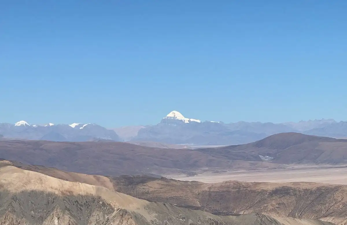
One of the most fascinating attractions on this route is Om Parvat. Unlike ordinary snow peaks, Om Parvat is famous because naturally formed snow patterns on the mountain resemble the sacred Hindu symbol “ॐ”.
During clear weather, travelers stopping near Navidhang can witness one of the most surreal views in the Kumaon Himalayas. For pilgrims, it is deeply spiritual. For photographers and expedition filmmakers, it is cinematic gold.


Lipulekh is globally known because it serves as one of the main Indian access routes for the sacred Kailash Mansarovar Yatra. Every year, selected pilgrims travel through this challenging Himalayan corridor toward Tibet to visit:
For Hindus, Buddhists, Jains, and Bon followers, the journey is considered spiritually transformative. The combination of altitude, isolation, and harsh weather turns the pilgrimage into both a physical and mental challenge.
Read More: – Spiti Valley Full Circuit: The Complete Route & Travel Plan
The ideal expedition window is generally:
Monsoon months can trigger dangerous landslides and road blockages. Winters often shut down major sections completely due to snowfall and extreme conditions.
Always verify local permissions and road status before planning the journey because the region remains strategically sensitive.


Beyond the adventure, the Lipulekh region also offers a rare look into Himalayan border culture. Small villages in the Byans Valley preserve centuries-old traditions shaped by trade, migration, and mountain survival.
For travelers willing to slow down, these villages reveal the human side of the Himalayas — something often missed during fast-paced road trips.
Lipulekh is also geopolitically significant because it sits near a tri-junction area involving India, Nepal, and China.
Due to its strategic position:
Travelers must respect local regulations, army instructions, and environmental sensitivity throughout the journey.
India’s overlanding culture is evolving rapidly. More travelers are moving beyond mainstream hill stations and searching for routes that offer real mountain exposure and authentic exploration Lipulekh represents exactly that future. Not luxury tourism, Not cafe hopping. and Not For Instagram tourism.
Real Himalayan expedition travel. The kind that tests your machine, your planning, and your mindset.
Read More:- Ladakh Expedition via Srinagar: Route, Plan & Full Circuit Breakdown
Lipulekh Pass is one of the last great frontier journeys in the Indian Himalayas. For the High Dairies community — people who live for overlanding, remote mountain routes, and off-grid exploration — Lipulekh is more than a pass.
It is a reminder that the Himalayas still hold roads capable of humbling even the most experienced travelers. And maybe that is exactly why explorers keep returning to the mountains.
Lipulekh Pass is located in the Pithoragarh district of Uttarakhand near the international borders of India, Nepal, and China. It lies in the eastern Kumaon Himalayas at an altitude of around 17,500 feet.
Lipulekh Pass is famous for being:
1. An ancient Himalayan trade route
2. One of the access routes for the Kailash Mansarovar Yatra
3. A strategic mountain pass near the India-China border
4. A remote high-altitude route popular among overlanders and expedition travelers
Lipulekh Pass sits at approximately 17,500 feet (5,334 meters) above sea level.
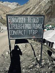
Access to the Lipulekh region is restricted due to its strategic border location. Travelers may require permits and approvals depending on current government regulations and route access conditions.
Dharchula is the nearest major town and serves as the primary base point for expeditions toward Lipulekh Pass.
The common route generally passes through:
Dharchula
Tawaghat
Malpa
Budhi
Gunji
Kalapani
Navidhang
The route includes rugged Himalayan terrain, narrow roads, and high-altitude sections.
Yes, Lipulekh Pass is considered one of India’s most challenging and rewarding high-altitude expedition routes for serious overlanders and 4×4 enthusiasts due to its remote terrain and extreme driving conditions.
The ideal time to explore the Lipulekh region is:
May to June
September to early October
Monsoon months are risky because of landslides, while winters often shut routes completely due to snowfall.
Om Parvat is a sacred mountain near the Lipulekh route known for naturally formed snow patterns resembling the Hindu symbol “ॐ”. Travelers heading toward Navidhang often stop to witness the mountain.
Yes, Lipulekh Pass is one of the traditional Indian routes used for the sacred Kailash Mansarovar pilgrimage toward Mount Kailash and Lake Manasarovar.
A reliable 4×4 SUV or high ground-clearance expedition vehicle is recommended because the roads can be rocky, narrow, and affected by landslides and weather damage.
Yes, permits and government approvals may be required due to the sensitive border location. Travelers should always check the latest regulations before planning the journey.
Yes, due to the extreme altitude, travelers may experience Acute Mountain Sickness (AMS). Proper acclimatization, hydration, and preparation are essential.
Mobile connectivity becomes extremely limited or unavailable in higher Himalayan regions near Gunji, Kalapani, and Navidhang.
Lipulekh Pass holds geopolitical importance because it lies near the India-Nepal-China tri-junction area. Military presence and security regulations are strong throughout the region.
Unlike mainstream Himalayan routes, Lipulekh offers: Raw expedition terrain, Minimal tourism infrastructure, Remote border-region landscapes, It is considered a true Himalayan frontier journey.